![]()
Where to run in the world > America > North America > United States of America > New York > New York City
New York City
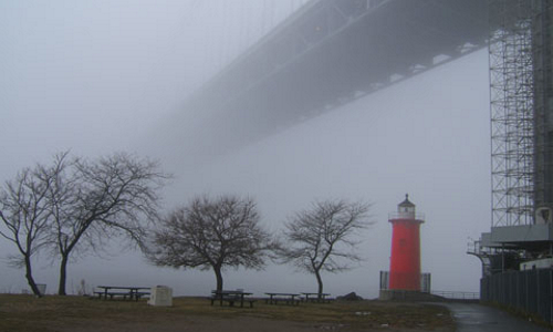
By Frank da Cruz - In the 1980s, before there was a Greenway and 12th Avenue was still the meat packing district, the viaduct was closed for renovation for about a year and you had to run along 12th Avenue to go north. I remember trying to hold my breath for ten blocks it is not easy but breathing was worse! Next to the elevated West Side Highway is an elevated railroad bed. Trains used to stop here and unload cattle for slaughter. Now the area is mostly deserted in anticipation of the construction of the new Columbia West Harlem ("Manhattanville") campus. Some trendy restaurants have opened up, but mainly it is like a ghost town. Previously the route from here north was the well-hidden Meridian Street. Now Meridian Street is blocked off and bypassed by another new landscaped Greenway section that goes from 135th to 145th Street, snaking around the construction and storage sheds through terrain that used to be overgrown with kudzu. That the shacks are still there lends a small touch of authenticity. At 145th Street the new path swings left and joins the upper Riverside Park path (if you go straight you will see what the path you just took used to look like). This is a major development because the stretch from 129th to 145th Street was one of the last missing links the Greenway on the West Side. Now you can run along the river all way from about 92nd Street (where there is another missing link) just about to the northern tip of Manhattan. From here you can run along the river through the upper 140s and the 150s, where there are big community cookouts on summer weekends with delicious smells and blasting merengue, salsa, and bachata that give you a jolt of energy. Riverside Park turns into Fort Washington Park at 155th Street, but you won't notice. Reportedly falcons live there. When you come to what seems to be the end of the path at about 165th Street at some baseball fields, turn right (East, away from the river) and the path continues around behind the fields, like a shady country lane along the railroad bed, and then comes out within sight of the Little Red Light House at the base of the bridge, which is one of the all-time great destinations. Sometimes you will find Port-A-Potties set up there, but don't count on it. There is also a big field house with bathrooms, but no fountain. The George Washington Bridge is awesome that's the only word that fits. You can't appreciate how huge it is until you approach its base on foot and look up and across from underneath. You can still keep going north from the Little Red Lighthouse. There are several ways. One way (not recommended) is through a hole in the fence onto the railroad bed; a long time ago when the tracks were abandoned and rusty I ran all the way up along the tracks to the railroad bridge that connects to the Metro North Spuyten Duyvil station in the Bronx (the low bridge that swings around to let ships pass). I figured I might as well cross so I could say I ran to the Bronx, but I soon discovered it was all burnt out only the rails and a few charred tie stumps were left, the rest was just air and that low bridge was higher than it looked! Then as I reached the halfway point, I lost the shelter of the cliffs and found myself hanging on for dear life in an 80-mph wind, like a flag. Well, somehow I got across to the Bronx and back but it wasn't graceful. Now the railroad is running again, so don't go this way. There are other ways to run to the Bronx! (Reportedly, white-tailed deer that have even less sense than I do have begun to make the dash across this bridge into Inwood Hill Park). You can also leave the trailroad tracks after a few hundred meters through another hole in the fence and take the path to Dyckman Street. It is quite rustic and "unimproved" I saw an osprey nesting there once long ago (like an eagle, that swoops down on the water and grabs fish with its talons). Eventually I came out into what seemed like waist-high dune grass and then there was a shingle house right on the water with lawn furniture and some boats; I thought I was in Nantucket! A bit farther on was a little gate that let out onto Dyckman Street. Anyway now there is a new (early 1990s) marina at the end of Dyckman Street, and the path from the bridge to Dyckman street is marked on the map as "Planned Greenway (to be constructed)" until then it remains a trail blazed by adventurers. In July my daughter Amy and I took the train to Dyckman Street, walked over to the river, tried without success to find where to get on the newly renovated running path along the highway, so went through the little gate instead and headed south. The new marina extends for some distance in this direction, and the shingle house is now a big metal shed housing the Inwood Boat and Canoe Club; it seems the original structure burned down in 1989. Anyway, the path is still rustic and unimproved, most of it through waist-high grass and thick vegetation. As it approaches the George Washington Bridge, there is a stretch where the river squeezes right up against the railroad bed, and you have to go through a hole in the fence and run for several hundred meters along the train tracks on big loose rocks no fun! Then you can scoot up a short but steep hill and join the paved walkway that goes down to the base of the bridge (or up to the West Side Highway). I found out later that the way to get on the new highway path from Dyckman street is to go up Staff Street, which angles up sharply from Dyckman just before the marina, on the left as you face the river. So, in summary, for the trip between (say) 110th and Dyckman Streets, there is a High Road (Riverside Drive and the West Side Highway) and a Low Road (along the river), so you can go one way and come back the other. Crossing points are at Dyckman itself, the George Washington Bridge, Riverbank State Park, and elsewhere if you are creative. The round trip is about 10 miles. By the way, if you are on Dyckman Street at the river, you can enter the large flat river-edge park north of Dyckman, the part of Inwood Hill Park that is west of the highway, that has several baseball fields and some great views, and hardly anybody who doesn't live in that area knows about it. It extends to the northernmost tip of Manhattan at Spuyten Duyvil, and you can run the length of it (about 2/3 mile) along the water. Photo by Jeff Bogumil.
![]() Runners who live in the Columbia University area of Manhattan, New York City (Morningside Heights and West Harlem) are fortunate to have Riverside Park, Central Park, and Morningside Park nearby. The parks and the Hudson riverfront are in better condition now than at any time in the last one hundred years, especially since 2000 with the inauguration of the Greenway. The site Upper Manhattan Running describes some obvious and not-so-obvious runs that start in the Columbia area, but it is also useful for anybody who lives on the west side anywhere between midtown and Washington Heights or Inwood.
Runners who live in the Columbia University area of Manhattan, New York City (Morningside Heights and West Harlem) are fortunate to have Riverside Park, Central Park, and Morningside Park nearby. The parks and the Hudson riverfront are in better condition now than at any time in the last one hundred years, especially since 2000 with the inauguration of the Greenway. The site Upper Manhattan Running describes some obvious and not-so-obvious runs that start in the Columbia area, but it is also useful for anybody who lives on the west side anywhere between midtown and Washington Heights or Inwood.
| Share your running suggestion - Do you have a course you would like to suggest and share with other runners like you? To add it, simply fill out our form. We will take care of illustrating your suggestion if you do not have a photo to go with your description. |