![]()
Where to run in Bouvet Island (Norway)
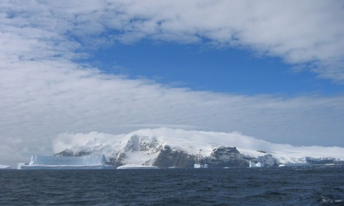
Although Bouvet Island and the adjacent territorial waters were designated a nature reserve in 1971, the island offers no safe running courses. It is 58.5 square kilometers (22.6 square miles) in area, 93% of which is covered by glaciers which block the south and east coasts. It has no ports or harbors, only offshore anchorages, and is difficult to approach. The glaciers form a thick ice layer falling in high cliffs into the sea or onto the black beaches of volcanic sand. The 29.6 kilometers (18.4 miles) of coastline are often surrounded by an ice pack. The highest point on the island is called Olavtoppen, whose peak is 780 meters (2,600 feet) above sea level. This uninhabited volcanic island was discovered in 1739 by a French naval officer after whom the island was named. Since 1977, Norway has run an automated meteorological station on the island. Bouvet Island is a candidate for the most remote island in the world. The nearest land is Queen Maud Land, Antarctica, over 1600 kilometers (1000 miles) away to the south, which is itself uninhabited.
| Where to run in the world > Antarctica > Bouvet Island > Bouvet Island (Norway) |
| Share your running suggestion - Do you have a course you would like to suggest and share with other runners like you? To add it, simply fill out our form. We will take care of illustrating your suggestion if you do not have a photo to go with your description. |
Since September 7, 2007 - ©
Aerostato, Seattle - All Rights Reserved.
JOIN THE WORLDWIDE RUNNING NETWORK