![]()
Where to run in the world > America > North America > United States of America > Missouri > Saint Louis
Saint Louis
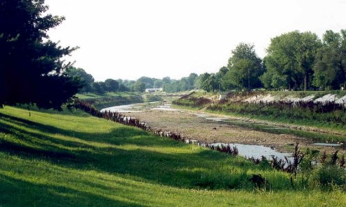
The greenway is the pilot project of the 1998 River Des Peres Beautification Plan, a joint project of the city, St. Louis County, Metropolitan St. Louis Sewer District, the Army Corps of Engineers and the East-West Gateway Coordinating Council. The new four-mile trail along the River Des Peres, built at a cost of $5.5 million by the Great Rivers Greenway District opened to foot traffic in 2005. Plans call for the trial to extend all the way to where the river converges with the Mississippi. Currently the trail starts at Morganford Road and runs parallel along the southwest side of River Des Peres to the new Shrewsberry MetroLink station. Numerous spur trails leave the path including one that takes walkers/runners through a peaceful corridor of mature trees and well kept fields to the intersection of Holly Hills Avenue and Christy Drive. Here Holly Hills Avenue can take you to Carondelet to add on a nice chunk of distance. Another option for those who would like to escape the pavement is on the northeast side of the river where a gravel access road lines the bank. This path is a lot easier on the legs and is usually a lot less crowded. The River Des Peres Greenway is a great place to get in some easy miles. Southside walkers and runners can be seen on the trail almost any hour of the day. We enjoy running the gravel trail on the north side of the river as it is a nice escape from the hard stuff. Directions: take I-55 to the Germania/Carondelet exit and head north along the river. Parking can be found on both sides as can the trail.
| Share your running suggestion - Do you have a course you would like to suggest and share with other runners like you? To add it, simply fill out our form. We will take care of illustrating your suggestion if you do not have a photo to go with your description. |